Residential
CLS Solutions, Inc. is pleased to offer a full array of surveying services for Southern California. Thanks to our many years of experience, our attention to detail and our commitment to stellar customer care, we have built a reputation as an industry leader in quality, accuracy and service. Whether you are buying and selling a home, developing a subdivision or business complex, installing a cellular tower or subdividing your land, we have the experience, resources and skills to ensure all relevant surveys are conducted in an accurate, affordable and timely manner.
Before you purchase a piece of residential property, your lender or title company may require a boundary survey to be performed on the land. With our many years of proven experience, CLS Solutions, Inc. has the expertise to conduct these boundary surveys thoroughly and accurately to ensure you are protected in any home or land purchase.
What Does A Boundary Survey Entail?
Boundary land surveys are among the most common types of surveys in use by the general public, in which the precise measurements of the boundaries of a piece of land are located or verified. This is actually a bit more complex than simply measuring out the physical boundaries of the land; a skilled land surveyor will also conduct extensive research to ensure the stated boundaries are correct.
The first step of a boundary survey is to review any existing records concerning the property, which may include title certificates, deeds and other papers. The surveyor researches prior boundary surveys, easements and other records that may influence his findings. Most of today’s homes are built on property that was sold after dividing up a larger piece of property; this can make the survey’s job more challenging, especially if this division was not surveyed or recorded properly.
Once the surveyor understands the historic boundaries of the property, he/she will take physical measurements on your land to determine whether the in-use boundaries confirm or conflict with the boundaries previously recorded. The surveyor may also set markers or stakes, if necessary, to simplify future surveys. Usually, a land surveyor will measure each location multiple times, averaging these results to determine the true position of the point.
After the measurements are complete and have been marked on your land, the surveyor may walk the property with you, pointing out the landmarks measuring each point and advising you on any differences between the current boundary survey and prior records, including any areas of conflict or encroachments with the neighboring properties.
When Is A Residential Boundary Survey Recommended?
For your protection, whenever you’re considering a purchase of residential property, it’s always a good idea to hire a land surveyor to perform a residential boundary survey, whether or not the lender or title company requires it.
You may also want to perform a survey on property you own if any of the following are true:
- If no prior survey records exist on the property (this is rare, but can be the case for properties that are held multi-generationally)
- If existing survey records are old or out of date
- If you suspect a neighbor is encroaching on your land
- If a neighbor accuses you of encroaching on his/her property
- If there are any doubts as to easement rights (for example, if you’re unsure whether a utility company has the right to run pipes or wires across your land)
- Anytime you need peace of mind as to your actual property boundariesDo You Need an ALTA Survey? https://www.nsps.us.com/page/ALTANSPSStandards
Whether you need a boundary survey for a property you’re purchasing or one you already own, CLS Solutions, Inc. sets the industry standard in customer service and excellence. With nearly a century of combined experience, our team stresses accuracy, customer service and quality work delivered on time, guaranteed. For more information or to obtain a quote, call us at 310-280-6439 or contact us here.

Topographic Land Survey:
Before undertaking any significant construction/development project or environmental improvement project, it may be necessary to perform a topographic land survey to identify various features and elevations of the land. CLS Solutions, Inc. has many years of experience in conducting these surveys with remarkably accurate results.
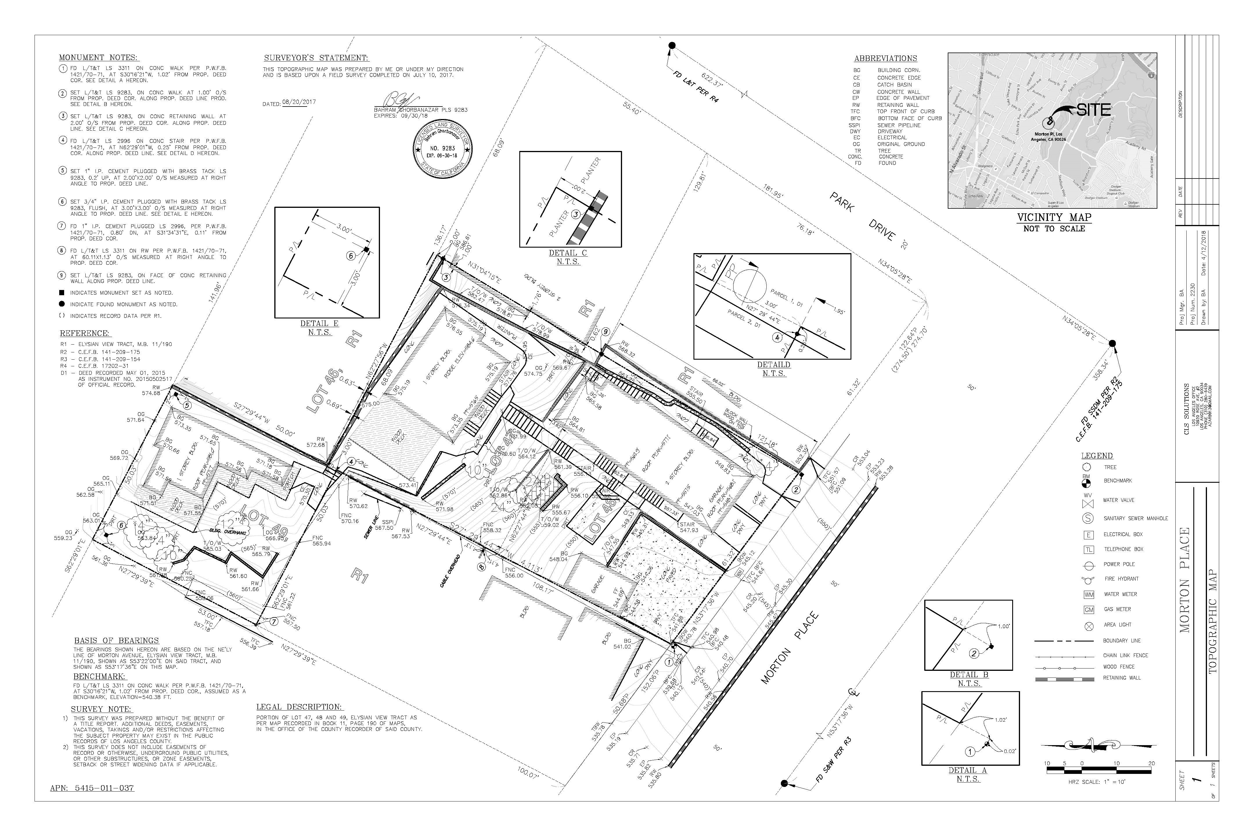
What Is A Topographic Land Survey?
While the standard land survey deals primarily with marking out the boundaries of a parcel of land, a topographic survey is primarily concerned with noting the natural and manmade features on the land itself. These may include hills, ravines, streams, trees, fences, buildings, and other improvements over the natural state of the land. A topographic survey shows the location, size, and height of these types of improvements, as well as gradual changes or contours in elevation. Unlike boundary or residential land surveys, a topographic land survey focuses more on elevation than on horizontal measurements. Most of these measurements are taken either with a surveying-quality GPS unit, or with an electronic EDM instrument. The results of the topographic survey are not marked using stakes or other landmarks, but are instead drawn as contour lines on a map of the land (topographic surveys are sometimes called contour surveys or Architectural Surveys). Today, sophisticated computer programs allow for digital versions of these maps, as well as interactive elevation views of the land. The data may be used in CAD programs, where it can be manipulated by engineers or architects to demonstrate how the topography will change through planned improvements. When Are Topographic Surveys Needed?
Topographic land surveys have many uses. Nearly all construction projects begin with a topographic land survey, which describes the starting point of the land before improvements are made. Engineers and architects use them as an aid in designing buildings or other improvements to be situated on the property, as existing features may influence their design or decisions on where structures can and cannot be placed on the property. Topographic surveys may also be used when creating plans for drainage ditches, grading or other features, using the natural landscape as the basis for such improvements. Government agencies may also require topographic surveys for any of a number of reasons—for example, as regulatory requirements for construction codes, or as part of environmental restoration projects.
Topographic land surveys are also useful when a parcel of land that was previously in use is being redeveloped—for example, an abandoned quarry or landfill, a site where a building was demolished, or on a site where the topographic data is changing. In these cases, a topographic survey provides an accurate view of how the land has been changed by its use, allowing for better planning for future use.
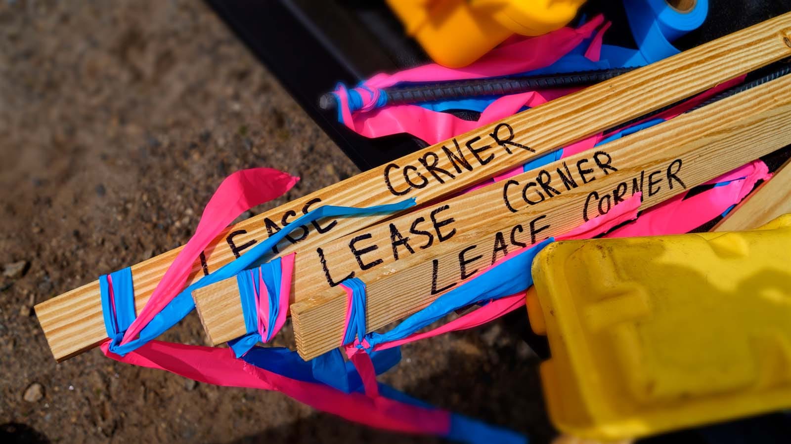
Construction Staking:
Before construction begins on any project, accurate construction staking is essential to prevent costly errors during the building process. CLS Solutions, Inc. is highly experienced in providing reliable construction staking services to ensure that your building project proceeds according to plan. What Is Construction Staking?
Sometimes also called a “site layout survey,” construction staking is essentially the act of creating a visual layout of the construction plans upon the property where the structures will be built. Referring to the construction plans, the surveyor will place stakes throughout the build site to mark the location and dimensions of each element and structure to be built. This includes not just building layouts, but also staking the locations of roads, concrete walkways, curbs, plumbing and drainage grades across the property. This visual staking enables the builders to locate each feature exactly where it is supposed to be placed on the site, keeping them compliant with the construction plans.
Why Construction Staking Is Important
When translating plans and blueprints to actual structures, accuracy is key to preventing costly mistakes. A commercial & residential construction project involves many elements interacting together, and the misplacement of a wall or pipe by inches or even centimeters can have serious repercussions across the rest of the project, causing time delays and expensive corrections. Construction staking helps reduce the risk of error by enabling everyone involved with the physical construction to see exactly where each element must be placed.
It stands to reason that for a construction project to be completed according to specifications, construction staking must be performed with the highest possible levels of accuracy, and only by a licensed and experienced surveyor. With our many years of experience and proven track record, CLS Solutions, Inc. can deliver the accurate results you need, on time and within budget. To learn more about our construction staking services, contact us today.
As-Built Surveys:
When building improvements upon residential property (such as a new structure or add- on), the builder or the local authorities may require one or more as-built surveys to ensure the construction is proceeding according to plan. CLS Solutions, Inc. can perform these surveys with a high level of accuracy to satisfy the requirements of local or state regulations and to help the contractor measure the progress of improvements.
Understanding As-Built Surveys
Unlike land or boundary surveys which measure the boundaries or features of the land itself, an as-built survey is designed to show any and all improvements to the land at a given point in time. Any residential construction or improvement project begins with a site plan which shows the location and dimensions of proposed improvements. For comparison, as-built surveys measure these improvements as they’re being built to ensure they are conforming to the proposed site plan. Depending on the size and scope of the project, as-built surveys may occur numerous times during construction, and again at completion, to make sure all aspects of the project have been constructed in the right way, and in the right place.
When Are As-Built Surveys Required Or Recommended?
Quite often, local or state zoning boards will require a certain number of as-built surveys during the course of a construction project to verify that improvements are complying with applicable regulations, as well as with any proposed plans already on file. The rules for these as-built surveys as to detail and frequency may vary according to local regulations and requirements. Even if local authorities don’t require them, however, a good contractor may call for an as-built survey several times during the course of the project to make sure the building is proceeding according to plan, as well as to measure the progress of construction against the projected timeline for completion. If mistakes or variances have occurred during construction, it’s much easier and less costly to make these adjustments along the way than after everything is completed.
Given all that is at stake, accuracy is critical when performing as-built surveys. For this reason, you should only hire a licensed land surveyor you can trust to get the job done right. To learn more about our quality residential as-built surveys and to obtain a quote, contact CLS Solutions today.